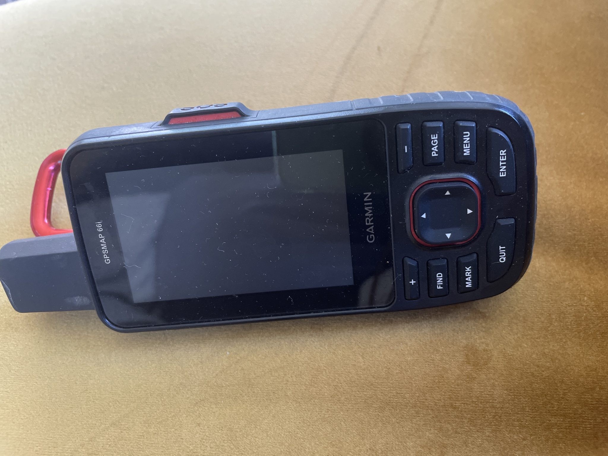
Garmin In-reach GPSMAP 66i
Approx $393.82 USD

The Garmin inReach GPSMAP 66i is a top-of-the-line handheld GPS device that combines advanced navigation, satellite communication, and robust durability into a single compact unit. Designed for adventurers, explorers, and outdoor enthusiasts, the inReach GPSMAP 66i ensures you stay connected and on track, even in the most remote and rugged environments.
Whether you're trekking through the wilderness, hiking across mountain ranges, or embarking on a remote backcountry adventure, the Garmin inReach GPSMAP 66i gives you peace of mind with its two-way satellite messaging, interactive SOS alerts, and global navigation capabilities. With this device, you can not only find your way but also stay in touch with loved ones or emergency responders wherever you go.
Key Features of the Garmin inReach GPSMAP 66i
1. Two-Way Satellite Communication
The inReach GPSMAP 66i is equipped with Iridium satellite technology, enabling global two-way messaging and interactive SOS alerts. This feature allows you to send and receive messages from anywhere in the world, even when you're out of cellular range. Whether you're checking in with family and friends, updating your status, or sending a distress signal in an emergency, this satellite communication feature ensures you're never out of touch.
2. Built-In GPS and GLONASS Navigation
The Garmin inReach GPSMAP 66i comes with a high-sensitivity GPS and GLONASS receiver, providing precise navigation even in challenging environments, such as dense forests, canyons, or mountain ranges. The GPSMAP 66i supports topo maps, road maps, and waypoints to help you navigate your journey with confidence.
Additionally, the device offers trackback functionality, which allows you to retrace your steps if you need to find your way back to a previous location.
3. Large, Color Display with Enhanced Mapping
The inReach GPSMAP 66i features a 3-inch color display that’s easy to read in both bright sunlight and low-light conditions. The high-resolution screen provides clear maps and intuitive controls, allowing you to zoom in on locations, plot courses, and monitor your progress during your adventure.
The preloaded topo maps offer detailed terrain information, including trails, roads, and rivers, helping you navigate remote areas more effectively. You can also download additional maps from the Garmin Explore app for even more mapping options.
4. Compact, Durable, and Water-Resistant
Built to withstand the elements, the Garmin inReach GPSMAP 66i is waterproof (IPX7 rated), shock-resistant, and rugged, ensuring it can handle the demands of outdoor adventures. Whether you're caught in the rain, crossing rivers, or hiking through rough terrain, this GPS device is designed to perform reliably in all conditions.
5. Long Battery Life
With up to 200 hours of battery life in tracking mode and up to 30 days in power saving mode, the inReach GPSMAP 66i ensures that you can rely on it for extended adventures without needing to recharge frequently. It also features a rechargeable lithium battery, which can be easily charged via USB for convenience.
6. InReach Activation Plans
To fully utilize the satellite communication capabilities, you’ll need to activate an inReach subscription plan. Garmin offers flexible month-to-month, annual, and pay-as-you-go plans that suit different levels of use, from occasional travelers to regular adventurers. These plans give you access to two-way messaging, tracking, and SOS alerts, giving you peace of mind wherever you go.
7. Garmin Explore App Integration
The Garmin inReach GPSMAP 66i integrates seamlessly with the Garmin Explore app. With the app, you can plan routes, view trip data, and share your location with friends and family. You can also sync your device with the app to get detailed weather updates, which can help you plan your outdoor activities more effectively.
8. Customizable Waypoints and Routes
With the inReach GPSMAP 66i, you can easily set waypoints, routes, and tracks to guide you during your adventure. You can plan your trip in advance or make adjustments on the go. The device also allows you to mark important locations and share coordinates, making it easier to navigate through difficult terrain and return to key spots.
9. SOS and Emergency Assistance
One of the standout features of the Garmin inReach GPSMAP 66i is its SOS functionality. In the event of an emergency, the device allows you to send an SOS signal to a 24/7 monitoring center, alerting emergency responders to your location. The interactive SOS feature also allows you to communicate directly with the monitoring center, giving you the ability to provide more details about your situation and receive assistance.
Why Choose the Garmin inReach GPSMAP 66i?
- Global communication with two-way messaging and interactive SOS alerts.
- Precise navigation with GPS and GLONASS technology.
- Durable design that can withstand extreme conditions.
- Extended battery life, making it perfect for long adventures.
- Large, readable display for easy map viewing and navigation.
- Seamless integration with the Garmin Explore app.
The Garmin inReach GPSMAP 66i is ideal for outdoor enthusiasts who need reliable navigation and communication tools, no matter where their journey takes them. Whether you're trekking through remote landscapes, embarking on a mountain expedition, or exploring unfamiliar terrain, this device ensures that you stay safe, connected, and on track throughout your adventure.
Description
-- INTERACTIVE SOS ALERTS Need assistance? Send interactive SOS alerts anytime, globally. -- TWO-WAY MESSAGING No matter where you are, two-way messaging lets you connect to the ones who matter. -- LOCATION SHARING Let loved ones know precisely where you’re roaming with location tracking and sharing. --100% GLOBAL IRIDIUM® SATELLITE NETWORK Instead of relying on cellphone coverage, now your messages, SOS alerts and tracking are transferred via the global Iridium satellite network --OPTIONAL INREACH WEATHER Use inReach connectivity to get detailed weather updates on GPSMAP 66i. Request weather forecasts for your current location, waypoints or destinations on your route. -- ACTIVE WEATHER When paired with your compatible smartphone, you can get real-time forecast information and live weather radar, so you’re always aware of the surrounding conditions. -- Get maps as pretty as a picture and just as detailed —without a subscription. -- Know the terrain before you’re in it, with preloaded TopoActive maps -- Stay out there longer with up to 35 hours of battery life in tracking mode and up to 200 hours in Expedition mode.
The product may be provided by a different brand of comparable quality.
The actual product may vary slightly from the image shown.


.jpg)


.jpeg)


.jpeg)


.jpeg)


.jpeg)


.jpeg)

.jpeg)

.jpeg)
.jpeg)


.jpeg)
.jpg)

.jpeg)


.jpeg)
.jpeg)


.jpeg)


.jpeg)

.jpeg)

.jpeg)

.jpeg)
.jpeg)


.jpeg)
.jpeg)
.jpeg)


.jpeg)


.jpeg)


.jpg)
.jpeg)


.jpg)


.jpeg)


.png)


.png)